IMH supports the Harts Cove Shipwrecks Project

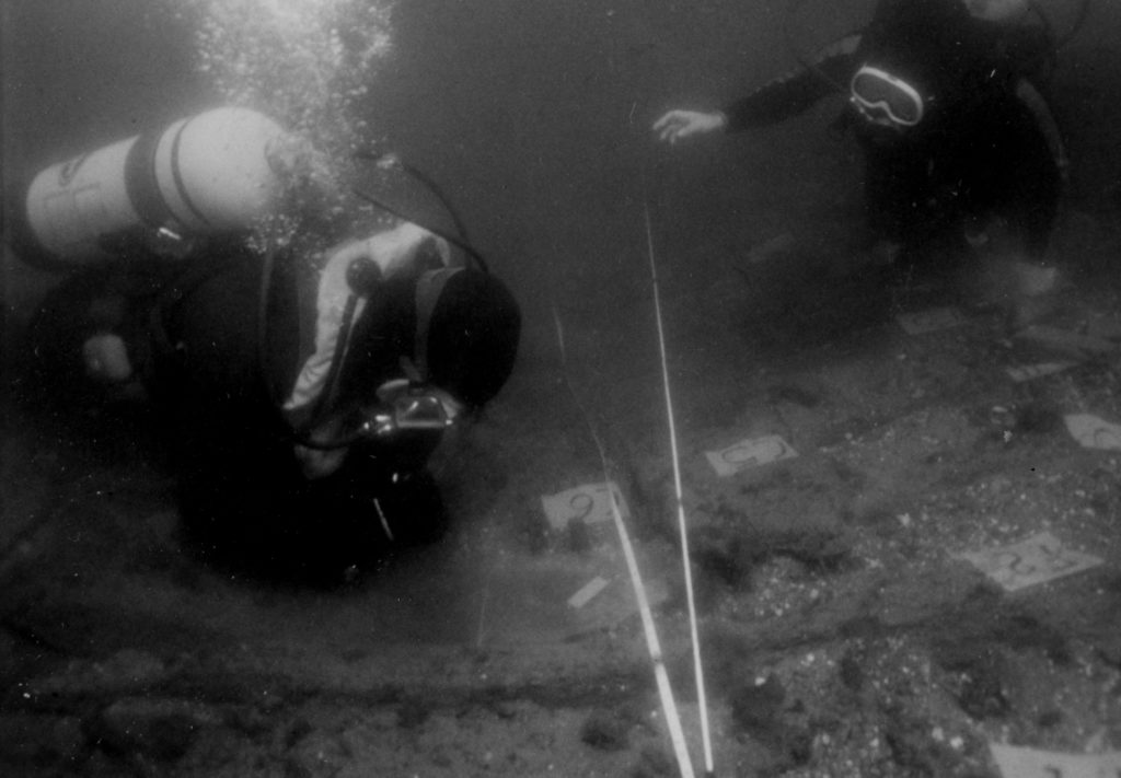
Underwater photo of the Harts Cove Shipwreck investigation and Plymouth State University field school in the 1990s under the direction of Dr. David Switzer (Courtesy Plymouth State University, Special Collections).

The Institute of Maritime History will assist Dr. Stefan Claesson in relocating two ca. 1700 shipwrecks in Harts Cove, New Hampshire.  The wrecks were salvaged by divers and investigated by archaeologists between the 1970s and 1990s, but the precise location of the wrecks was never reported.  The goals of this project are to re-locate the wrecks for the State for management purposes, document exposed elements of the sites using photogrammetry, and conduct wood sampling of visible ship timbers. These samples will be used to identify wood species used in the construction of the vessels and to obtain dendrochronological data that would aid in dating the construction of the ships.  We look forward to seeing the team’s results!

Dunmore reprise

During the fall and winter of 2014 and spring of 2015 we will resume our search for any remains of Lord Dunmore’s “Floating City” from 1776.  See attached summary.

2014 fieldwork plans, updated

IMH’s field projects for 2014 include the following —

1    Help Scott Tucker assess a 1680s site (done)
2    Search for eight sites in St Mary’s River for Maryland Historical Trust (July)
2a  Inspect a storm anchor in St Mary’s River, Maryland (July)
3    Assess a dozen WWI wooden steamers at Widewater, Virginia (September – October)
3a  Assess 14 Pootomac sites en route to Widewater (September)
4    Continue mapping Civil War wrecks at Quantico, Virginia (October)
5    Resume search for Lord Dunmore wrecks at St George Island, Maryland (July – Augusr and November)
6    Help LAMP search for French wrecks from 1565 off Florida (July – August)
7    Assess possible SS “Express” (1878) wreck near Patuxent River, Maryland (August – September?)

Specific dates will depend on weather and participants.  For more information or to join in fieldwork please click the “contact” button in the top right corner of this page and say which projects interest you.

2014 fieldwork plans

World War One started 100 years ago this August.  As we reach its centennial, IMH plans to map and assess the remains of approximately 15 large, wooden steamships from that war.  They were built for the US Shipping Board’s Emergency Fleet Corporation, and now lie submerged or partially exposed in an area of the Potomac River called Widewater, near Aquia Creek and near Mallows Bay, Maryland, where more than 150 of their sisters were burned for scrap in the 1920s.  We will also search for other wrecks in the vicinity, assess perhaps 15 more sites in transit, and report all findings to the Maryland Historical Trust or the Virginia Department of Historic Resources, depending on site locations.

Fieldwork is scheduled for the period from 13 September to 5 October.  This project will provide an excellent opportunity to engage volunteer divers in the assessment of a large number of large wrecks from a crucially historic period whose effects are still keenly felt today, in an area that is geographically convenient to Washington DC, and in diving conditions that are benign, if somewhat turbid.

Please review the attached project summary.  Then, if you are interested in participating, either click the “Contact” button above, or email david.howe@maritimehistory.org.


Chesapeake and Delaware reconnaisance, autumn 2012

During September and October 2012, IMH plans to continue an underwater reconnaissance in the Delaware River for several American warships and one British warship that were sunk in 1777.  Our work will support the efforts of Andrew Doria – The First Salute, Inc., to build a replica of the brigantine Andrew Doria, one of the vessels lost.  She was one of the first four vessels purchased by Congress for the Continental Navy in 1775.  The project will be coordinated with the State of New Jersey and the U.S. Naval History and Heritage Command.

On our way to the Delaware and back we will also reconnoiter 88 possible shipwrecks in the Chesapeake Bay for the Maryland Historical Trust (MHT).  Five of the sites are in the Potomac, and 83 are in the Bay.  We have scanned many of them in prior transits, but have only dived a few.  Many of them may never have been dived.  The sites lie along 147 miles of transit from Tall Timbers MD to the C&D Canal.  Site data will be reported to MHT and nobody else.

Scanning will employ IMH’s hard-mounted sidescan sonar.  When conditions and manpower allow, we will also use a Marine Sonic Technologies “Splash Proof PC” sonar on loan from the National Park Service.  The Marine Magnetics “Explorer” magnetometer that was used in the first part of the project in April and May 2012 is not currently operational, but we will use it if it is repaired in time.  Participants can gain as much “scope time” as they want.

Targets selected by MHT will be dived by IMH volunteers, manually mapped, and scanned with metal detectors.  To maximize volunteer participation, those dives would be conducted on weekends and clustered geographically to meet divers.  The transit schedule would be adjusted to suit.  The project depends on IMH receiving funds to work in the Delaware River.  The Chesapeake work could then be performed along the way at minimal cost to participants.

Participation requires the usual diving waivers plus your agreement not to disturb sites, not to move or remove anything, and not to tell anyone outside the project where we went or what we found.  No take, no talk.

The tentative schedule is to depart Tall Timbers on 17 September, scan the Chesapeake sites 17-21 September, work the Revolutionary War sites 22-30 September, scan some Delaware Bay sites 1-6 October, show the IMH flag at Coast Day at Lewes on 7 October, work with the University of. Delaware for a few days to map a large shipwreck at Cape Henlopen, and dive the Chesapeake sites from (say) 10 October until Hallowe’en.
 

Wooden pegs and Volunteers

Only late yesterday did we discover any definite fasteners on top of the keel. Attached is a close-up of a wooden peg, or treenail, in the center at the top of the keel. We only found two of them, both at the northern end of the vessel. Perhaps they attached a stem or sternpost.

More Investigations in Seal Cove

It has been a flurry of activity in Seal Cove. We mapped the entire wreck with the exception of a timber that we will record tomorrow. We had volunteers lending a hand all week. As many as nine at a time. It has been a success as an outreach project, with several people having their first experience in maritime archaeology on the wreck. Volunteers learned trilateration, baseline offsets, drew profiles, measured frames and photographed fasteners. I gave a talk on maritime archaeology at the Schoodic Education and Research Center Wednesday night. On Thursday afternoon Park staff searched the William O. Sawtelle Curatorial Center and found several excellent historic photos of the cove, two showing a mill that might have been associated with the wreck. We found sawdust, as well as tar, coal, and brick fragments, near the keel.

Seal Cove Shipwreck Project: volunteer!

As part of the Seal Cove Shipwreck Project we are going to be recording a shipwreck in the intertidal zone in Seal Cove, Maine, August 1-5. This is an IMH project in conjunction with Acadia National Park. Learn the basics for mapping and documenting a wreck site by working with maritime archaeologists. Potential volunteer activities could include making archaeological drawings of the vessel, recording the site in photographs, and transferring the field drawings onto a site plan. If you are interested in volunteering, please contact Rebecca Cole-Will, Cultural Resources Program Manager at Acadia National Park; rebecca_cole-will@nps.gov; (207) 288-8728.