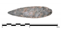
Prehistoric stone biface: The Lunt biface (ca. 9,000 years old) recovered by scallop fishermen in Blue Hill Bay, Maine in the 1990s.
In 2007-2008, IMH participated in a 2-year submerged prehistoric landscape survey in Maine under the direction of Stefan Claesson and the University of New Hampshire (UNH). Supported by a grant from NOAA’s Office of Ocean Exploration and Research, the survey explored a region of Blue Hill Bay, Maine for the presence of submerged prehistoric landscapes and archaeological sites. The survey used multibeam sonar, parametric sub-bottom acoustics, and seafloor coring to identify relict submerged landforms, and develop high-resolution data visualizations and models. The survey was also intended to establish effective survey techniques for detecting the presence of submerged prehistoric landscapes and to assess the preservation potential for submerged archaeological sites and relict landscapes in the Gulf of Maine. Furthermore, the project sought to improve scientific as well as public understanding of regional geology, sea level and climatic changes, and how these regional environmental conditions may have affected the initial peopling of the northeastern U.S. To complement these efforts, IMH formed a SHIP chapter in Maine to assist with public outreach and education activities.
